Fine Art. Antique Prints, Maps and Drawings
Por Dahlströms Fine Art
Contactar a la casa de subasta
5.4.25
Grönviksvägen 124167 76 BrommaSweden, Suecia
Términos y condiciones de venta
Ver demostración
La subasta ha concluído
|
LOTE 18:
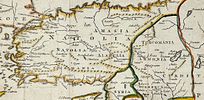
Thomas Jefferys (c. 1719–1771) - Turkey - The Ottoman Empire's Asian territories; Turkey In Asia with Cyprus - 1751-1760
más...
|
|


|
Precio inicial:
300
Skr
Precio estimado :
2 000 Skr - 3 000 Skr
Comisión de la casa de subasta: 23%
|
Thomas Jefferys (c. 1719–1771) - Turkey - The Ottoman Empire's Asian territories; Turkey In Asia with Cyprus - 1751-1760
Decorative regional map, showing provinces, islands, towns, etc. Decorative cartouche.Thomas Jefferys (c. 1719-1771) was an English cartographer and engraver, known for his detailed maps of North America and the West Indies. He was the official geographer to King George III and produced many important maps during the 18th century. Jefferys played a significant role in mapping British territories, including early maps of Canada and the American colonies. His work remains highly regarded for its accuracy and historical significance in the study of colonial geography.Dimensions25 cm x 18 cmArtist or MakerThomas JefferysMediumLithographyDate1754Condition Report:This work is in good condition overall. There may be a few minor imperfections or fox or mottled marks to be expected with age. Please review the images carefully for condition details, and feel free to contact us with any questions or for a comprehensive condition report.
